
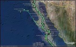
Baja 1000 2009 course map in Google Earth.
For a closer look, download a zipped version of the Google Earth .kml file here.
Baja 1000 2009 course map in Google Earth.
For a closer look, download a zipped version of the Google Earth .kml file here.

The 44 mile course pulled from the GPS track.
I think this is the only race we do where we actually get to sleep in. Everyone will start to gather out at the pits in a bit. Scott and Carrie will do prerunning on motorcycles. Sometime this afternoon is the driver’s meeting and then those of us not in the car head out to Road Crossing 11 to control traffic when the cars come through.
I’ll be updating via Twitter throughtout the day at @desertdingo . Her’s the KML file that you can download and plug into
Tricked-out VW revs up for Baja 1000
CNET News.com November 9, 2007
The Baja 1000 route, as depicted on a Google Earth map. The off-road race begins November 10 in Ensenada, Mexico, and traverses 1,300 miles. Teams have 53 hours to complete the course. They cannot go more than 60 mph on the highway, and GPS tracks the teams to ensure compliance.